
Citizen comment: The intersection of Hunter and Wonderworld is deadly and needs to be fixed. The speaker kept mentioning “new paint” as a solution, which made me think that she specifically meant that weird little island blocking what used to be the right turn lane from Wonderworld, north onto Hunter (on the corner with the CVS store.) I’m glad we’ve added bike lanes, but I also see cars bumble over that island every time I’m at that intersection. And there do seem to be a lot of accidents.
Item 11-12: Annexation and zoning 65 acres on the corner of Rattler Road and McCarty. It’s this little red square with the star in it:

We’ve seen this area several times recently. It’s been a zoning bonanza:
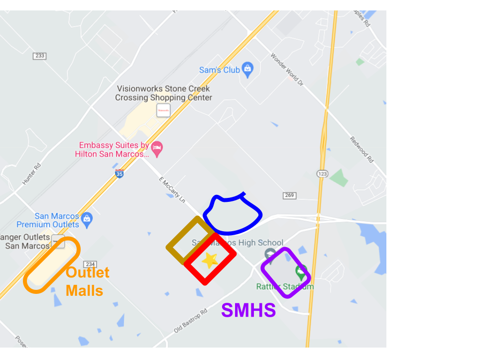
Back in September, these other folks wanted (and got) a cut-and-fill exemption for that blue region. And back in August, the neighboring property (in that yellow-puke color) was zoned CD-5. It’s going to be apartments. (Also, a gigantic development was approved behind the outlet malls at that same meeting.)
The red rectangle is proposed to be CD-4. In that zoning, you’re allowed to build duplexes, townhomes, apartments, cottage courts, and other things that are denser than traditional neighborhoods but still feel small scale. (But you can also just build apartments, I think.)
The red rectangle and the yellow-puke rectangle are owned by the same people. So they’re selling the city on a larger vision where the yellow-puke one is dense, traditional apartments, and then this red one is more varied with all the duplexes and townhomes. Sort of transitional in scale towards single family houses.
Is this a good idea? Let’s apply our criteria:
Price Tag to the City: Will it bring in taxes that pay for itself, over the lifespan of the infrastructure and future repair? How much will it cost to extend roads, utilities, on fire and police coverage, on water and wastewater?
This is a good spot for infill. There is already infrastructure and coverage for this area.
Housing stock: How long will it take to build? How much housing will it provide? What is the forecasted housing deficit at that point? Is it targeting a price-point that serves what San Marcos needs?
Some day, the planning department will read my blog and hastily fall all over themselves in an effort to answer this question.
Environment: Is it on the aquifer? Is it in a flood zone? Will it create run off into the river? Are we looking at sprawl? Is it uniformly single-family homes?
Not on the aquifer. Not in a flood zone. No run off to the river or any other environmental hazards, as far as I can tell.
Given the duplexes, townhomes, apartments, cottage courts, and other things, it has the potential to be very good. It won’t be uniformly single-family detached houses.
Social: Is it meaningfully mixed income? Is it near existing SMCISD schools and amenities?
It is very close to SMHS, and not that far from Goodnight and elementary schools.
As for whether it’s mixed income, that depends on the developer. If the developer takes advantage of what they’re allowed to build, it could be mixed income. But just because they sell a compelling vision during the approval phase does not make it binding.
The San Marxist Special: Is it a mixed-income blend of single family houses, four-plexes, and eight-plexes, all mixed together? With schools, shops, restaurants, and public community space sprinkled throughout?
The larger region has the potential to become this. We shall see.
Final judgement: It sounds mostly good. Go for it.
…
So what did council do?
There was a little discussion about including a buffer at the back of the property, as a courtesy for the homes right there, which are outside city limits. Staff will bring back a proposal at the next meeting.
And then they voted, and it passed 7-0. (Where’d the clickers go?)
I personally think this project passed all the criteria with flying colors. But you know Max would have had a dozen questions about it. Perhaps all the questions got settled in Secret Executive sessions – it’s just really hard to know.
…
Item 13: Trace PDD
A few months ago, we did a deep dive into La Cima. Time for a Trace Deep Dive? Let’s do it.
Trace was approved in October 2015. It’s about 417 acres big:
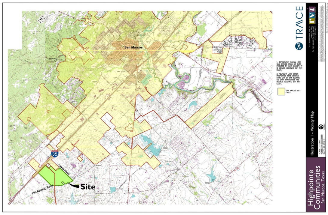
That’s not my usual chicken-scratch map – this is the map from the developers. I love our city staff, but their maps are truly for shit.
It’s supposed to be a whole community – houses, apartments, parks, an elementary school, some stores. Mixed income. My only real gripe is that it contributes to sprawl – you’re kinda far from everything out there.
In 2017, there was a bond election to fund an elementary school there, and Rodriguez elementary school opened in August 2019.
It was next amended in 2019 and 2022. All the amendments were kind of finicky and detail-oriented – what should the heights of the apartment buildings be? Can we relocate sidewalks to this other side of the street? That sort of thing.
On the whole, it seems fine. It seems to need far fewer tweaks than La Cima or Whisper. (At some point, we’ll have to unpack Whisper Tract.)
…
So what’s up now? It’s coming up because they want to rezone part of it. Here’s the original zoning of Trace:

The dark orange part facing I-35 is General Commercial, about 44 acres.
Now they want to convert about 37 of those acres to apartments:
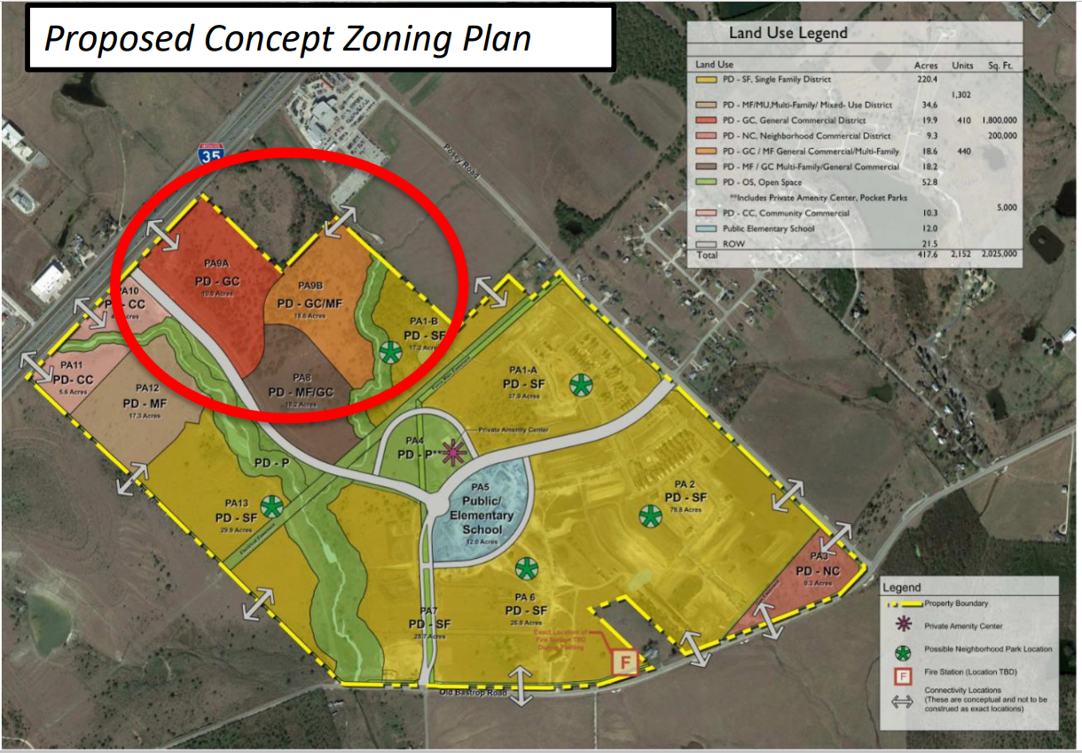
Both the light orange and brown parts of that red circle could now be apartments.
Is this good or bad? It’s complicated. At the P&Z meeting in December, Griffin Spell an excellent point: yes, we need housing. But Trace has not fully built the apartment complexes that they’re already allowed to build.
Furthermore, we also need amenities on the east side. It is a huge problem in this town that the east side lacks an HEB and the normal sort of shopping options. People are constantly talking to council and P&Z members about needing more commercial on the east side.
Griffin’s point is basically, “Let the developers finish building the apartment complexes that they’ve already agreed to build. If they still can’t find commercial occupants at that point, they can bring the rezoning back.”
The developer basically says, “Unfortunately, commercial is just not viable in that spot! It’s not visible from I-35!”
To which Griffen dryly responds, “You’re the one that put it there back in 2015, and nothing has changed since it was approved.”
The developer gave a weasely answer about communities maturing. It left me with the impression that they always planned on converting it to apartments, and the original commercial zoning was just there to make it look good.
So what did council do?
At City Council, there was no discussion of this point at all. They just approved it, 7-0. It gives the impression that they are not scrutinizing developers at all. The issue Griffin raised is complex, and at least deserves some air time. On this item, I’m giving the stink-eye to this new Max-less council.
