Citizen Comment:
Two big topics! (I’m combining comments from 3 pm and 6 pm.)
Cape’s Dam nomination to be on the historic registry:
- 5 people opposed
- No one in favor
The Data Center
- 2 people (both developers) in favor
- 10 people opposed.
Details on what people actually said when we get to these!
Other comments:
- Update on the San Pedro cemetery: replacing historic pillars, repairing fences, surveying property bounds. Issues of drainage and erosion. We support low impact development nearby, but we’re concerned about something busier.
- Kissing Tree gets called wealthy, but we worked for decades. We pay a lot in taxes. We need good jobs to fix poverty. Yay development!
- San Marcos Civics Club is going to start issuing environmental score cards for each council member.
- Support for naming the new airport road after Lieutenant Colonel George C Carruthers
…
Item 8: Cape’s Dam
This item was pretty infuriating!
It’s also not the most important thing ever? I’m trying to keep perspective? I was irritated, but this is small potatoes.
Backstory:
From 1867-1942, Cape’s Dam was a functioning dam. The dam creates a calm little side channel to the river, called the Mill Race:
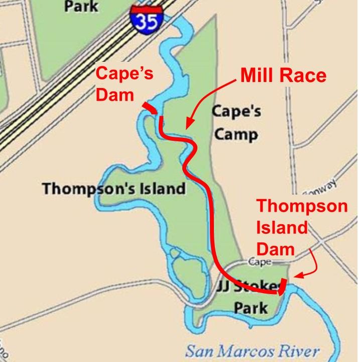
Since the dam closed, the Mill Race has basically been treated as quasi-private property for kayak and paddling retreats.
The Army Corps of Engineers often likes to remove old dams. In the 2000s, the folks at the Meadow’s Center started working on this study saying Cape’s Dam is bad for endangered species.
Around 2015, Council is looking at whether they should remove the dam. But before they decide, Cape’s Dam is destroyed by the 2015 floods. It’s now dangerous. The Mill Race is also not usable anymore.
2016: Council approves removing the dam and filling the Mill Race. The federal government will pay for it.
This turns into a huge controversy. There’s a campaign launched – Save the SMTX River! – challenging the Meadow’s Center report and saying they’ve got different scientists who say different things. They basically want the Mill Race to be preserved for recreation, but they’re making an environmental argument? and a historical argument?
(Incidentally, the Save the SMTX River guy is also one of the Brighter Future for San Marcos PAC guys.)
Council backtracks on their decision. The federal funding expires.
…
Everything grinds to a halt for a decade. Council keeps passing the hot potato.
Ten years go by. In the meantime:
- The San Marcos River Foundation (SMRF) acquires the land on the south side of the dam
- Research about slave labor building the Mill Race gets traction.
- Hays County signs on, and they seem to want the dam rebuilt
- A teenager loses his life when he gets caught in the rebar of the damage
…
This past March, Council finally dusted this whole issue off.
They authorized a feasibility study, to answer these questions:
- What’s the current conditions of the dam and the whole area?
- What would it take to rebuild it? Or partially re-build it? Or just remove it?
- What’s the environmental situation? What’s the permitting process?
- Do a bunch of public outreach and get public feedback.
I can already tell you some answers!
- The current dam has to first be removed, whether or not it is rebuilt afterwards.
- You cannot rebuild without permission from SMRF, because they own half the land, and they have said many times that they are a hard no.
- You cannot rebuild without lots and lots of money, which we do not have.
This will all come to a boil in the next few months! Exciting times. (Full backstory here.)
…
Which brings us to tonight! Cape’s Dam has been nominated for placement on the national historical registry.
Is there a legitimate historical claim?
Kind of yes! The area was has a historical plaque with the Texas Historical Commission from 1979, in 1985 it was declared eligible for the National Register, and in 2017, it was included with a broader number of dams declared eligible for inclusion in the National Register. In addition, there’s credible evidence by a Texas State prof about the role of slave labor in building the dam.
So what’s new tonight?
Preservation Texas is nominating the Thompson-Cape Dam and Millrace to actually be on the National Register of Historic Places.
…
Lots of things about this are irritating!
- This is a rush job. You can submit nominations every three months, but the nomination people are determined to submit by the January 16th deadline. This one is URGENT, full stop, no flexibility.
- Whoever is behind this is keeping their name hidden*. The nomination came from Preservation Texas. No one with local ties has put their name on it in any way.
- The complex already has plenty of historical recognition! There is no new development.
- All land owners are supposed to consent, but SMRF was not notified, and has not consented.
*Aren’t I the biggest hypocrite! I also love hiding out in shady anonymity. I’m a jerk.
….
How does that long, tiring backstory affect Council’s thinking on this issue?
Council: LALALALALALA WE CAN’T HEAR YOU!
Basically, Council members all pretend to be brand new babies born yesterday, who have never heard of the 10 year fight I just told you about.
The most generous interpretation: council members are willing to nobly set aside long-standing feuds, and consider this on its merits.
The least generous interpretation: council members are gleefully taking part in a craven attempt to sway the larger outcome by miring it in bureaucracy.
You be the judge!
…
What did people say at Citizen Comment?
- This is a ruse to force Council to rebuild the dam.
- The dam is full of contemporary materials, like concrete sandbags
- No effort has been made since 1950 to preserve the historic nature of the dam
- This was a timber dam, which is a low cost, quick dam
- There are 8 other dams on the river, and they’re also all super old
And most importantly, the San Marcos River Foundation: Look, we own the land on one side of the bank, and we were not notified. The rules require that all owners give consent. We didn’t.
…
Council discussion!
Jane: What exactly do they need from us?
Answer: The Texas Historical Commission (THC) wants two letters – one from Council and one from the San Marcos Historical Preservation Committee (HPC) – saying they support the nomination.
Jane: Can we postpone this? It seems very rushed. The State Board reviews these every three months. Can we just wait till March?
Answer: The applicant specifically said they are not willing to postpone until March.
Amanda: Yes, this seems very rushed. What about just waiting until after the San Marcos HPC meets, and hear what they recommend?
Answer: Usually yes. We prefer to have committees present their recommendations to Council. But the timing doesn’t work out. SM-HPC will meet on Jan. 8th, and then you all don’t meet until Jan 20th. But the letter is due Jan 16.
Saul: The dam is not even close to the original structure. It’s got cement sandbags. I’m a no.
Lorenzo: I’m a yes! Wouldn’t that be great for people to see SAN MARCOS on the national historic register, when tourists come to town?
Jane: Why didn’t the people who nominated this reach out to the city? Where are they? We have a priority list of historical places. This leap-frogged over a bunch of other places on our list.
Saul: Would this prevent us from making a decision about whether to rebuild or remove the dam?
Answer: It carries political weight, but not legal weight.
In other words: this vote sends a message to the public about which side your bread is buttered on. But it’s not legally binding. You’re allowed to tear down the dam.
Amanda: This nomination provides a specific historical narrative. It was white-washed to make white people look like noble saviors of enslaved people. If we send a letter of support, then that’s the version that will end up in the national registry.
Alyssa: Yes, they’ve romanticized it.
Jane: That’s why I want to send a very minimal letter. We won’t address the historical narrative part of the application. We’ll just say, “Yes, there is a historical element!”
Alyssa: Omissions are just as bad! That’s how status quos continue to flourish! Whatever is in this application will be the skeleton of the final narrative. That’s how these things work.
Jane: Then let’s just be vague!
Alyssa: That doesn’t make sense as a response to what I’m saying. We’re writing a letter in support of a nomination.
Jane: I’m trying to be minimal!
Alyssa: …which will be interpreted as support, unless we’re explicit about what we don’t agree with.
Matthew: None of this matters!
Shane: What’s the harm?
Lorenzo: Surely the Historic Registry will do their due diligence. Let’s just pass this and let them do the heavy lifting.
Amanda: I want the narrative to acknowledge the role of enslaved people.
Matthew: The Cape family did not own slaves!
Jane: The whole slavery thing is very contentious. Different people think different things.
Amanda: Slavery is actually in the nomination already. Didn’t you guys read it? I just don’t like how they handled the topic.
Amanda is correct:

and

Alyssa: Clearly this is going to pass, so I’m going to suggest some language for the letter.
Proposed language, after some tinkering:
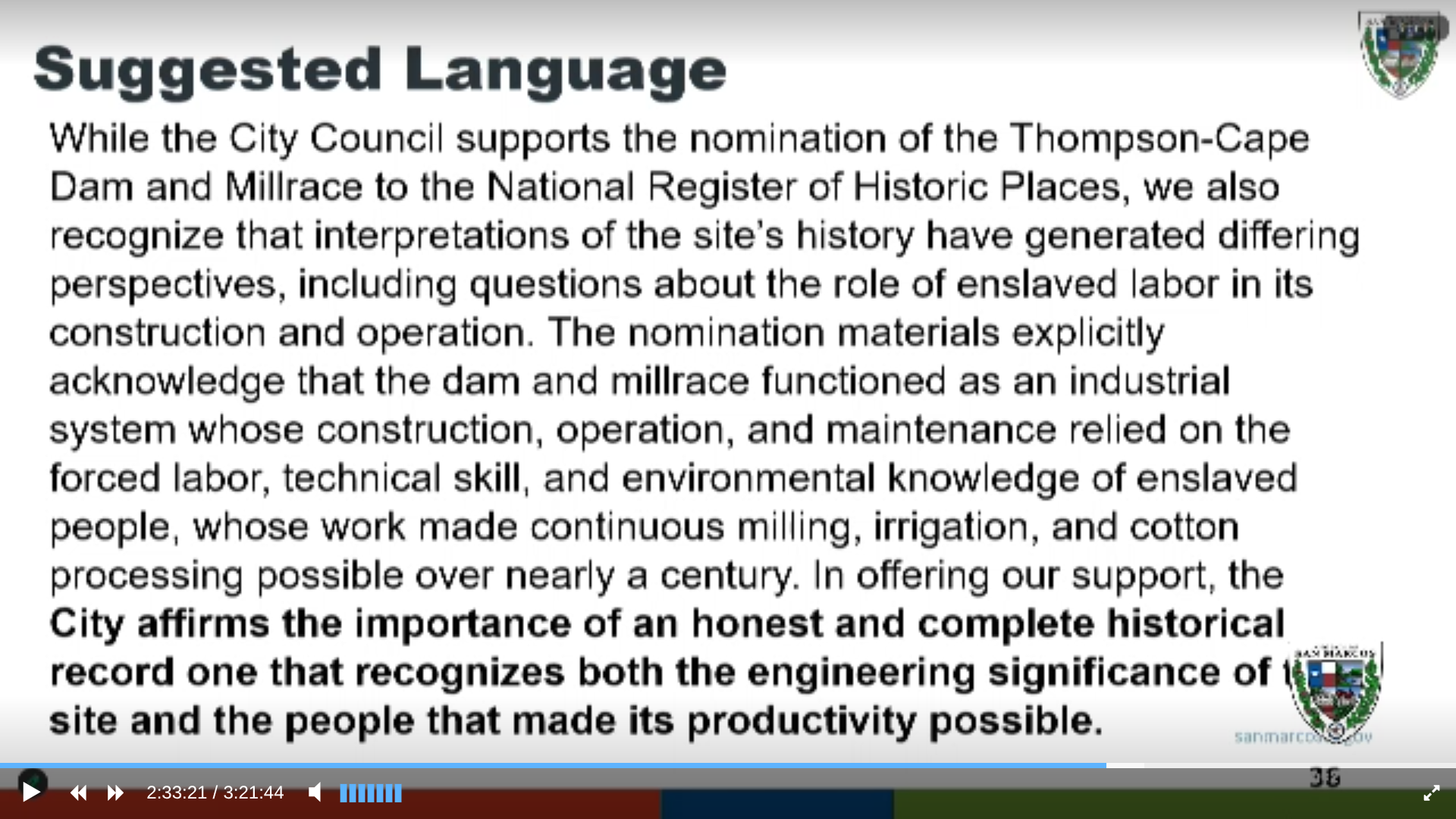
They also include a note about how SMRF wasn’t notified.
The vote: Should we support the super urgent nomination that absolutely cannot wait until March?

So there you have it.
…..
Finally, let’s have a little reality check!
The national registry is a big deal. Currently there are four historic landmarks for central Texas on the national register:
- The San Antonio Missions
- LBJ’s childhood home
- El Camino Real trail
- Mammoth Caves in Waco

Will Cape’s Dam be the 5th most historic thing in the entire greater Austin-San Antonio corridor?!?
Seems unlikely. Like I said, this is small potatoes.
…
Item 9: The Data Center
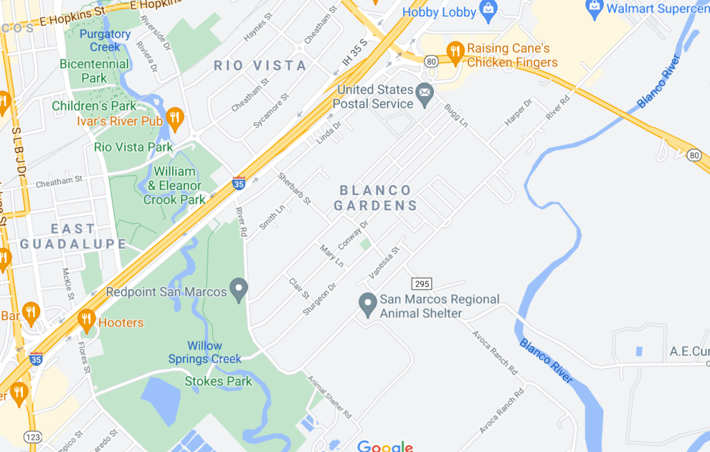
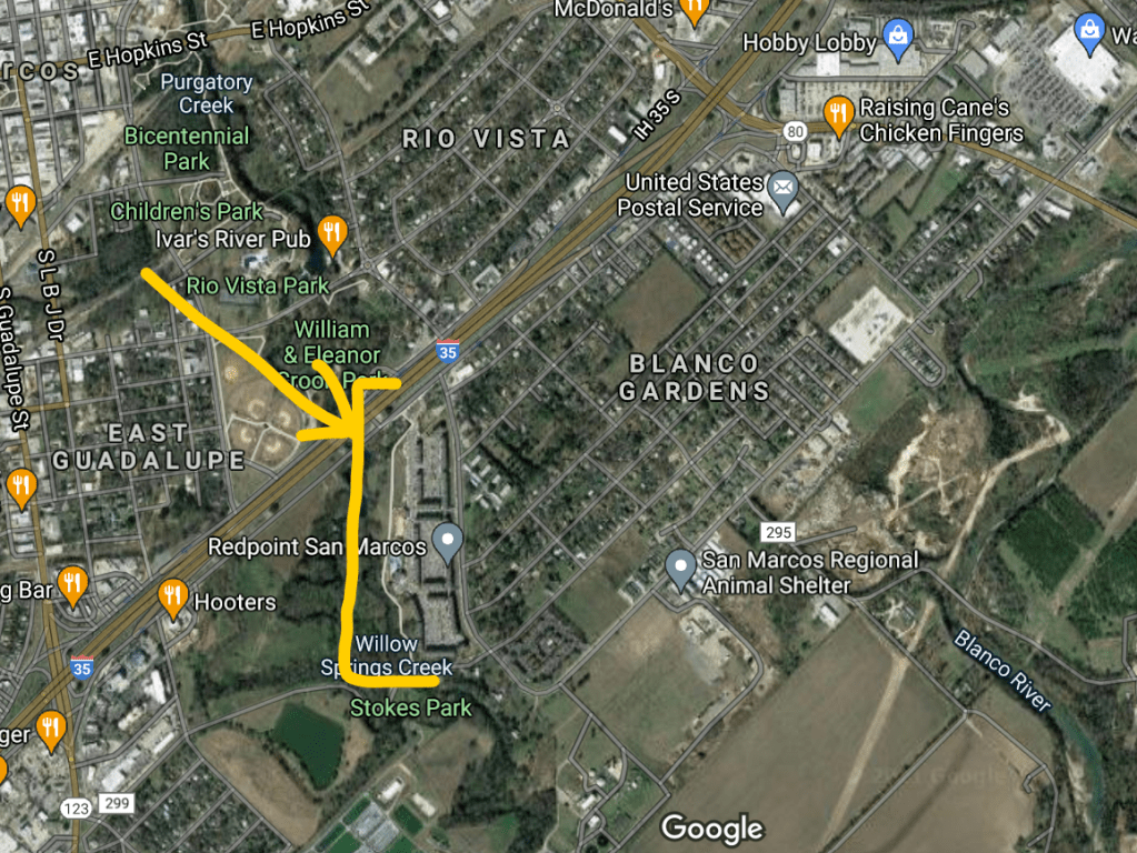
Backstory: This developer, Mayberry, bought some land down here, a few years ago:

Right next to the Hays County Power Plant:

He wanted to build some homes. It turns out this was a terrible investment. Now he’d rather build a data center, instead. Could he please have a rezoning?
The town responded HARD against this. People who live on nearby farms say it will ruin their way of life. People are worried about extreme water use during a drought and heavy electrical use from the shaky ERCOT grid. Tons of people have put in a lot of effort into fighting this data center.
Last spring, P&Z turned him down. It went to Council in August, and Council didn’t have enough votes to overturn P&Z. So it failed.
However, Council did not put the final nail in the coffin. They left a trail of breadcrumbs for Mayberry to come back.
He dutifully followed the trail, and here we are. (Full version of the backstory here.)
Tonight is just a presentation.
Mayberry is back. Here’s the timeline:

His pitch is going to be that he will sweeten the deal via a restrictive covenant.
Here’s what he’s proposing:


We don’t have the formal contract yet, though.
The two big issues are water and electricity.
Water: Texas has a big water shortfall. The 2022 State Water Plan projected big shortfalls, and everyone is working with those numbers. But ChatGPT didn’t come out until November 2022. There are now already over 400 data centers in Texas. The water use from these data centers is not included in the 2022 projections, but it’s all we’ve got.
This data center would get their water from Crystal Clear. Crystal Clear gets their water from:
- Edwards aquifer
- Lake Dunlap
- Carrizo-wilcox
- SM River
By 2040, Crystal Clear is projected to be -40 acre-feet of of water. As in, they don’t have enough water rights to cover projected demand. And that’s using the 2022 pre-data center usage projections! Crystal Clear cannot deny service either. (This info was from an expert at citizen comment.)
The proposal here is not the worst possible proposal. Evaporative cooling systems are the worst. This is a closed-loop cooling system. (I have no idea how many of the 400 data centers are evaporative.)
Mayberry is estimating that they’ll use 25K-30K gallons of water per day, and they’ll put a hard cap at 75K gallons per day in the contract. That’s equivalent to the water used by about 235 homes. (Evaporative cooling centers are probably in the 100K-500K gallons per day range.)
Electricity
There’s a tradeoff between water and electricity. If you use less water, you’ll use more electricity. In addition, the Texas ERCOT grid uses water to cool the electrical generation plants.
There is a longterm solution here – the more ERCOT switches to solar and wind-based energy, the less water needed to generate the electricity. (This is already cheap and available, if we want it.)
Will utility rates rise? It depends on who you get your electricity from. This plant will be on Pedernales electric, so if you are too, then yes, it’s likely your rates will rise, too. But if you’re on San Marcos city utilities, your rates will not go up (yet).
….
My $0.02: I’m conflicted, but I’m still basically in favor of this data center.
Argument in favor: the data center industry is an absolute goddamn disaster for Texas. There are almost 100 between San Antonio and Austin. There are already four in the Hays-Caldwell area. This is catastrophic for the water shortage.
But it is not a city fight. The heart of the problem is that Texas counties cannot regulate water and electricity usage. If we care about the water shortage and strain on the electrical grid, we have to fight that fight. Fight for county regulations of water and electricity use, and statewide data center regulation.
In the meantime, we might as well take the tax revenue.
Argument against: Maybe denying this one data center contributes momentum to a bigger movement against the other 400+ statewide?
Listen, all you activists: You are on the right side of the issue, but you absolutely must join forces on a larger scale. The only meaningful answer is regional and statewide regulation.
If I had to guess, good places to start might be:
- This group, the Food & Water Watch, is calling for a national moratorium on data centers.
- These are the groups in Texas that signed onto their letter:
- Climate Conversation Brazoria County
- Frontera Water Protectors
- Hold the Line Campaign
- Texas Physicians for Social Responsibility
- Turtle Island Restoration Network
- These guys are focused on resisting data centers in the South, and have an organizer toolkit.
- Show up and make your case to your state senator and representative
City Councils are much closer to everyday people than regional and state organizations are, but Council cannot move the needle on the problem. Any progress has got to deal with county land, outside of cities.
…
Just for kicks, how much money are we talking?
I don’t really believe those numbers. It takes years to build these things, markets can crash, etc etc. But still, a fraction of that tax revenue would be helpful.