Cheat Sheet for VisionSMTX Survey

VisionSMTX Survey can be found here. Survey is open until Friday, February 23rd.

CHEAT SHEET OPTION 1: The 30-second version:
1. Go here.
2. Click the blue circle on the left that says “Vision SMTX Poll”
3. Select “Original Draft Plan” and submit.

CHEAT SHEET OPTIONS 2 and 3: The 5-minute version and 30-minute version

Should you trust me?  Only if you agree with me!Here’s my basic position:

  1. I do not like economic segregation.  Most of the P&Z edits were made to ensure that the only people who live in quiet, residential neighborhoods are people who can afford to rent or own an entire house.  I would like small-scale rentals in quiet neighborhoods. The best ways to do this are with Accessory Dwelling Units (ADUs) and little 2, 3, or 4-plexes. You can make them look like houses, even! 
  1. I do not like traffic and pollution.  People drive less if there are stores and amenities within easy walking or biking distance. Everyone on the east side of 35 has been asking for more commerce for YEARS and YEARS. 

    A small neighborhood grocery store and restaurant doesn’t fit in the 1980s Suburbs Dream, but can’t we move past that? Wouldn’t it be nice to easily pick up a pack of diapers or some dog food?
  1. I do not like sprawl.  The changes above – small-scale rentals and nearby commerce – are both examples of “gentle densification”.  The Historic district is the best example of what the goal is. 

    Sprawl makes for higher taxes, because the city has to cover a very large footprint with utilities, SMPD, and firefighters. Sprawl is expensive and unsustainable. Gentle densification is a sustainable solution.

CHEAT SHEET OPTION 2: the quick version, the biggest topics

1. Go here.
2. Click the blue circle on the left that says “Vision SMTX Poll”
3. Select “Original Draft Plan”
4. In the first comment box, cut and paste the following recommended language:

Topic: Commerce and amenities close to residences (complete communities)

Recommended language: “Please change items #13, 14, 20, 23, 24, 26, 27, 34, 39, 40, 61, 64, 69, 72, 74, and 79 to reflect my preference for having commerce and amenities within walking distance of where people live.”

Topic: Small-scale rentals in quiet neighborhoods

Recommended language: “Please change items #8, 9, 16, 17, 33, 35, 36, 37, 38, 38A, 38B, 66, 72, 74, 79, 81, 87, and 88 to reflect my preference for having compatible, small-scale rentals available in quiet, single family neighborhoods.”

5. Then finish and submit.

CHEAT SHEET OPTION 3:  the long version, going item by item. 

The two topics above are by far the biggest topics. However, there are a bunch of topics that come up on 1-2 items:

  • Environment
  • Sprawl/Traffic 
  • Tenants rights
  • Equitable growth
  • Biking and trails
  • Housing shortage
  • Walkability
  • Layout of city

Below, I’ve organized the individual items by topic. I started with the smaller topics, and then put all the items from Commerce and amenities close to residences (complete communities) and Small-scale rentals in quiet neighborhoods at the end.

Feel free to cut and paste any of these, as much as you want!

Environment

Item 6:  Yes on adopting a dark skies ordinance. This change is good.

Item 19: Yes on language protecting water quality and preserving recharge of groundwater, and protecting environmentally sensitive areas.  This change is good.

Item 47:  Yes on language about how parking structures allow for less horizontal surface space dedicated to surface parking. Please include “Explore other ways to reduce the horizontal surface space dedicated to surface parking.”

Sprawl/Traffic

Item 20: Remove “vehicle trip” from first bullet point about 15-minute travel time

Item 45: Revert to original. Put language back in about the drawbacks of existing mixed use low areas.

Item 56: Restore 2nd sentence, about how San Marcos would have housing demands outpacing employment growth under the alternative scenario.

Item 78: Yes on the new language, giving the impact of sprawl on police response times and travel times.

Item 91: Restore definition of Transit Oriented Development

Item 92: Restore definition of Transit Supportive Development

Tenants rights

Item 10: Yes on initiatives to promote programs and provide education on tenant rights and responsibilities. 

Equitable growth

Item 21: Put “equitable” back in the sentence where it was removed. (“Provide access to parks” back to “Provide equitable access to parks…”)

Item 27: Restore sentence about the problems of incomplete communities.

Item 28: Restore the clause “and promote a more equitable distribution of mixed use places”

Item 80: This definition is terrible. It uses the word “equitable” but whoever wrote it is not clear on what “equitable” means. Specifically, this definition implies that the goal for equitable growth is to treat everyone equally.  This should be scrapped, and the original definition of “equitable” from Item 82 should be restored.

Item 82: Restore the definition of “equitable”.

Biking and trails

Item 21: Restore the phrase “and to encourage active transportation” to the first sentence.

Housing shortage

Item 58: Restore the 2nd sentence, about how higher intensity areas will accommodate a lot of housing and employment needs.

Walkability

Item 20: Remove “vehicle trip” from first bullet point about 15-minute travel time

Item 59: Restore first sentence, about ensuring a high level of walkability with places to walk near most residences.

Layout of city

Item 62: Restore map images – they are helpful for at least some of us. 

Item 93: Yes on edits – keep Guadalupe and LBJ as 1-way streets.

The two big topics:

Topic: Commerce and amenities close to residences (complete communities)

  Item 13: Revert to original, stronger language.

Item 14: Change “Consider” back to “Allow”.

Item 20: Remove “vehicle trip” from first bullet point about 15-minute travel time

Item 23: Restore “investments and” to the first sentence. Restore the last sentence about complete places and communities.

Item  24: Restore two sentences.  

Item  26: Restore first and second sentences to the original. (Edits to 4th sentence are fine.)

Item  27: Restore description of incomplete communities.

Item  34: Restore “To achieve the goal of truly Complete Communities, …” 

Item  39: Restore description of Neighbohood Medium Place Type. I don’t see anywhere else with a description this useful.

Item 40: Restore ADUs to Primary Land Use.

Item 59: Restore first sentence, about ensuring a high level of walkability with places to walk near most residences.

Item  61: Restore the deleted clause about complete communities.

Item  64:  Restore “and residential”, “that are walkable”,  “in or”, and “They should be concentrated to small geographies and distributed throughout the city”.

Item  69:  Restore the last deleted clause, “that will contribute to creating more complete communities throughout San Marcos”.

Item  72: Restore the bullet about implementing VisionSMTX goals and policies on a neighborhood scale. Allowing neighborhood plans to shut down city goals can cause NIMBY collective-action problems.

Item  74: Restore the original final sentence on Area Plans.

Item  79: This is a useful definition to include, but there is no definition of 15-minute cities in this table.  Include a conventional definition of 15-minute cities, using walking or biking but not vehicles.

Small-scale rentals in quiet neighborhoods

Item 8: Revert 2nd, 3rd, and 4th paragraphs back to original form.

Item 9: Re-included HN 2.2, and restore original language for HN 2.3 and HN 2.4.

Item 16: Keep “and incentivize” and “to accessory dwelling units”. (The edit adding “micro homes” is fine.) Delete the last sentence – I do not want neighborhoods to be able to prevent affordable small-scale housing options from being located in them.

Item 17: The new sentence will be fine if the following language is included: “but this shall not be interpreted to infringe on whether compatible infill can be subdivided into smaller, more affordable units.”

Item  33: Re-include sentence about small scale multiplex and ADUs.

Item 35: the short descriptions are fine, but should not replace the more meaningful descriptions of place types in items 38,38A, 38B, 39, 41, 43, 44, 45, 49, 51, and 53. Please restore originals in those items. 

Item 36: Area Plans and Neighborhood Character Studies should not be allowed to prevent affordable small-scale housing options from being located in them.  Large-scale, yes.  Requiring a compatible exterior is also fine.  But not effectively prohibiting them altogether.

Item 37: Graphics for Nbd Low-Existing should include ADUs and small-scale rentals, of the kind of example that exists in the Historic District currently.

Item 38: Include ADUs and small-scale multifamily in Neighborhood Low-Existing. 

Item 38A: The deleted paragraph for the old Nbd-Low should be used for Nbd-Low-Existing. The new writing in 38A should be deleted. Small multiplexes should be included under secondary land uses.

Item 38B: Since this is just for new neighborhoods, please be more assertive with what we would like developers to build. Suggested language to insert: “San Marcos recognizes the damage caused by single-family sprawl.  New residential neighborhoods should not be homogenous single-family products.  Developers should include gentle densification and economic integration by including small scale rental options intermixed with traditional homes. Commerce should also be planned within a 15-minute walk or bike from homes.” 

Item  66: Delete this sentence. Instead include, “The single-family nature of traditional neighborhoods was designed to exclude based on race and/or wealth. Renters should have opportunities to live and raise children in quiet neighborhoods. Small-scale rentals can add opportunities for affordable housing, while preserving the quiet nature of traditional single-family neighborhoods.” 

Item  72: Restore the bullet about implementing VisionSMTX goals and policies on a neighborhood scale. I do not want neighborhoods to be able to prevent affordable small-scale housing options from being located in them.  Allowing neighborhood plans to shut down city goals can cause NIMBY collective-action problems.

Item  74: Restore the original final sentence on Area Plans.

Item  81: Restore the definition of Cottage Cluster.  These are great affordable options for renters, especially with children.

Item  87: Restore definition of Middle Density

Item  88: Restore definition of Missing Middle Housing

Hours 0:00-1:01

Citizen comment: The intersection of Hunter and Wonderworld is deadly and needs to be fixed. The speaker kept mentioning “new paint” as a solution, which made me think that she specifically meant that weird little island blocking what used to be the right turn lane from Wonderworld, north onto Hunter (on the corner with the CVS store.) I’m glad we’ve added bike lanes, but I also see cars bumble over that island every time I’m at that intersection. And there do seem to be a lot of accidents.

Item 11-12:  Annexation and zoning 65 acres on the corner of Rattler Road and McCarty. It’s this little red square with the star in it:

We’ve seen this area several times recently. It’s been a zoning bonanza:

  Back in September, these other folks wanted (and got) a cut-and-fill exemption for that blue region.  And back in August, the neighboring property (in that yellow-puke color) was zoned CD-5. It’s going to be apartments. (Also, a gigantic development was approved behind the outlet malls at that same meeting.)

The red rectangle is proposed to be CD-4. In that zoning, you’re allowed to build duplexes, townhomes, apartments, cottage courts, and other things that are denser than traditional neighborhoods but still feel small scale. (But you can also just build apartments, I think.)

The red rectangle and the yellow-puke rectangle are owned by the same people. So they’re selling the city on a larger vision where the yellow-puke one is dense, traditional apartments, and then this red one is more varied with all the duplexes and townhomes. Sort of transitional in scale towards single family houses.

Is this a good idea? Let’s apply our criteria:

Price Tag to the City: Will it bring in taxes that pay for itself, over the lifespan of the infrastructure and future repair? How much will it cost to extend roads, utilities, on fire and police coverage, on water and wastewater?

This is a good spot for infill. There is already infrastructure and coverage for this area.

Housing stock: How long will it take to build? How much housing will it provide? What is the forecasted housing deficit at that point? Is it targeting a price-point that serves what San Marcos needs?

Some day, the planning department will read my blog and hastily fall all over themselves in an effort to answer this question.

Environment: Is it on the aquifer? Is it in a flood zone? Will it create run off into the river? Are we looking at sprawl? Is it uniformly single-family homes?

Not on the aquifer. Not in a flood zone. No run off to the river or any other environmental hazards, as far as I can tell.

Given the duplexes, townhomes, apartments, cottage courts, and other things, it has the potential to be very good. It won’t be uniformly single-family detached houses.

Social: Is it meaningfully mixed income? Is it near existing SMCISD schools and amenities?

It is very close to SMHS, and not that far from Goodnight and elementary schools.

As for whether it’s mixed income, that depends on the developer. If the developer takes advantage of what they’re allowed to build, it could be mixed income. But just because they sell a compelling vision during the approval phase does not make it binding.

The San Marxist Special: Is it a mixed-income blend of single family houses, four-plexes, and eight-plexes, all mixed together? With schools, shops, restaurants, and public community space sprinkled throughout?

The larger region has the potential to become this. We shall see.

Final judgement: It sounds mostly good. Go for it.

So what did council do?  

There was a little discussion about including a buffer at the back of the property, as a courtesy for the homes right there, which are outside city limits. Staff will bring back a proposal at the next meeting.

And then they voted, and it passed 7-0. (Where’d the clickers go?)

I personally think this project passed all the criteria with flying colors.  But you know Max would have had a dozen questions about it.  Perhaps all the questions got settled in Secret Executive sessions – it’s just really hard to know.

Item 13: Trace PDD

A few months ago, we did a deep dive into La Cima.  Time for a Trace Deep Dive? Let’s do it.

Trace was approved in October 2015.  It’s about 417 acres big: 

That’s not my usual chicken-scratch map – this is the map from the developers. I love our city staff, but their maps are truly for shit.

It’s supposed to be a whole community – houses, apartments, parks, an elementary school, some stores. Mixed income. My only real gripe is that it contributes to sprawl – you’re kinda far from everything out there.

In 2017, there was a bond election to fund an elementary school there, and Rodriguez elementary school opened in August 2019.  

 It was next amended in 2019 and 2022.  All the amendments were kind of finicky and detail-oriented – what should the heights of the apartment buildings be? Can we relocate sidewalks to this other side of the street? That sort of thing.

On the whole, it seems fine. It seems to need far fewer tweaks than La Cima or Whisper. (At some point, we’ll have to unpack Whisper Tract.)

So what’s up now? It’s coming up because they want to rezone part of it. Here’s the original zoning of Trace:

The dark orange part facing I-35 is General Commercial, about 44 acres.  

Now they want to convert about 37 of those acres to apartments:

Both the light orange and brown parts of that red circle could now be apartments.  

Is this good or bad?  It’s complicated.  At the P&Z meeting in December, Griffin Spell an excellent point:  yes, we need housing. But Trace has not fully built the apartment complexes that they’re already allowed to build.

Furthermore, we also need amenities on the east side.  It is a huge problem in this town that the east side lacks an HEB and the normal sort of shopping options.  People are constantly talking to council and P&Z members about needing more commercial on the east side.

Griffin’s point is basically, “Let the developers finish building the apartment complexes that they’ve already agreed to build. If they still can’t find commercial occupants at that point, they can bring the rezoning back.”

The developer basically says, “Unfortunately, commercial is just not viable in that spot! It’s not visible from I-35!” 

To which Griffen dryly responds, “You’re the one that put it there back in 2015, and nothing has changed since it was approved.”

The developer gave a weasely answer about communities maturing. It left me with the impression that they always planned on converting it to apartments, and the original commercial zoning was just there to make it look good.

So what did council do?

At City Council, there was no discussion of this point at all. They just approved it, 7-0.   It gives the impression that they are not scrutinizing developers at all.  The issue Griffin raised is complex, and at least deserves some air time. On this item, I’m giving the stink-eye to this new Max-less council.

Hours 0:00-1:18, 10/3/22

Items 15-16:  38.5 acres is being annexed and zoned.  La Cima is growing.  

I found myself wanting to do a deep dive on La Cima. How did we get here?  I thought maybe I could try to finally wrap my head around La Cima.  (I’d also like to do this for Whisper Tract and Trace.)

So La Cima was first approved in 2013, as Lazy Oaks. Most of the city’s online archives only go back to 2014 though, so I literally can’t find a map of the original parcel. It was 1,396 acres in size.

In 2014, it grows to 2,029.023 acres (and maybe gets renamed?) It looked like so:

That’s RR12 right at the entrance of the pink part, right where Old 12 meets new 12.

Basic stats, 2014:
– 2,400 houses
– 32.4 acres parkland
– 800 acres conservation
– 2,029 total acres

I think they actually start building houses in 2017.

The second amendment appears to be May 15th, 2018.  

Now it looks like this: 

So in 2014, that tan part – all residential houses – didn’t wrap around to the left of the conservation open space, and now it does. Plus they added apartment complexes. (I’m okay with the apartment complexes being added! I don’t like developing over the aquifer, but I don’t want it to be a cloister of wealthy people, either.)

Basic stats, 2018:
– 2800 dwelling units: old 2,400 houses + 400 new apartment units
– 35.6 acres parkland
– 791 acres conservation
– 2,029 old acres + 394 new acres = 2,423 total acres

In August of 2020, it grows again:

Adding that new pink part in the lower right hand side.

Basic stats, 2020:
– Still 2800 dwelling units
– 37.66 acres parkland
– 800 acres conservation
– 2,423 old acres + 129 new acres = 2,552 total acres

In November 2021, we added amended it to allow for the film studio. The plan seems to be for it to go in that new pink section on the lower right.

Of course, the fights weren’t until the following June, when everyone was super pissed about building on the aquifer. Listen: they are absolutely correct to be mad! It’s just that the fight wasn’t held at the correct time, legally speaking. By this point, City Council was just trading environmental protections for tax credits.

The funny thing is that the really big change came just one month earlier, and no one paid any attention.

This is in May, 2022, and it’s a pretty drastic change:

It jumped clear across RR12!!  That whole tri-colored bit on the upper right is brand new!

So what happened? A lot of housing was relocated. That light green piece in the upper left used to be residential, but now it’s conservation. So there are good parts and bad parts.

Basic stats, 2022:
– 4200 houses, 980 apartments
– 37.66 acres parkland
– 792 acres conservation 1227.8 = 2019.8 acres conservation
– 2,552 old acres + 1296 new acres = 3848 total acres

So: is this a good thing? 

I don’t know. It’s a complicated thing. There’s a lot more conservation, but a lot more building and living on the aquifer. I feel weird about it.

(Wasn’t I paying attention last May? Apparently not! I listened to the entire meeting and did not have a single thing to say about La Cima! You probably shouldn’t trust me very much.)

Also, not that much of it has actually gotten built yet. They’re chipping away at it.

So now we’re all up to speed on La Cima. So what actually happened last Tuesday?   A very a small bit, 38.5 acres, is finally getting annexed and zoned:

That pink square is my best guess of where it is.

Max Baker attempts to persuade the developer to use something water-friendly: either purple pipe or rainwater detention. He gets brushed off for both, in a slightly condescending way.

The vote:
Yes: Everyone except Max
No: Max

………………

Item 17: There’s an application to rezone 1.35 acres in the middle of Blanco Gardens.

 Here’s Blanco Gardens, and they want to rezone this pink square:

So really RIGHT in the middle of Blanco Gardens.  Aren’t there houses right there already?

Yes. This is a block full of houses, but it happens to have some undeveloped land interior to it, and the developer wants to add houses inside the block.

Some important details:

  • They can already develop it, SF6, which means single family housing with lots at least 6000 sq ft big.
  • They want SF4.5, single family housing with lots at least 4500 sq ft. 

So they can fit in more houses under SF4.5 Staff estimates that they could fit 8 houses at SF6, and 11 houses at SF4.5.

Other important details:

  • WE HAD A BIG FLOOD A FEW YEARS AGO, IN THIS EXACT NEIGHBORHOOD. And a few years before that. And a few years before that. Etc.
  • P&Z denied this request! So it would take 6 councilmembers to overturn it.

City council also denies it, 7-0, so that is that.  The developer can still build their SF6 houses if they want (and if they want to piss off the neighborhood).  

Item 19: Here is El Centro:

They’re good people!

The School Board officially gave that land to El Centro Cultural recently, and then came to find out that there’s a weird alley running through the school that still belongs to the city.

So we got a charming history of this alley – before SMCISD was SMCISD, it was the San Marcos Public Free School system.  Then in 40s, it spun off.  Gradually the city gave SMCISD bits and pieces of this land, through the 70s.  But there was still this one alley on the books (but never built).  

So we have officially abandoned the alley, which can then be given to SMCISD, which can then be given to the good people over at El Centro.

San Marcos City Council Elections are Problematic

Why are San Marcos City Council elections so bad?

First, every person in the city can vote for every city council position.  (In other words, they’re all at-large.)  At-large elections have a very problematic, racist past.  Generally, it works like this: Suppose your city is 70% white and 30% black.  The white majority can elect their favorite candidate in every single council election, and so a city ends up electing a 100% white city council.  

What’s the solution? Usually, single-member districts. This means dividing the city into six equal parts, and each part gets to elect one city council member. We do this for school board elections already. (Probably the mayor would still be elected at-large.) If we had single-member districts, then the candidate would have to live in the district they represented, so we would have city council members from all over San Marcos. It’s also easier on the candidate, because they can focus on a smaller region and concentrate their efforts.

So, lawsuits get filed. The SMCISD school board was sued in the mid-90s for having all at-large elections. (Could not find any record of it online, beyond #60 listed here by the lawyer who brought the lawsuit. That’s when they went to 5 single-member districts and 2 at-large positions.) Austin, San Antonio, New Braunfels, and Seguin are all single-member districts because they’ve all been sued or struggled over it.  Austin here, San Antonio here. There’s a whole chapter on Seguin here. And here is a fascinating Washington Post article from 1983, on MALDEF bringing lawsuits against Lockhardt, Corpus Christi, and Lubbock. The last sentence in the article is:

Last week MALDEF filed suits affecting city council systems in Pecos and Port Lavaca, and school districts in New Braunfels, Port Lavaca and Pecos.

So there you have it: 1983.  ANYWAY. Who still has all at-large districts in 2022? We do! Boo, hiss! 

But wait! There’s more! We have a peculiar system of declaring places.  Right now, we have four candidates for city council – Max Baker, Matt Mendoza, Saul Gonzalez, and Adam Arndt.  Suppose my favorite candidates are Max and Matt, and I don’t like Saul or Adam.  Well, I’m stuck, because Place 1 is Max vs Matt, and Place 2 is Saul vs Adam.  I can’t vote for my favorite slate of candidates.  That’s not the best way to elect a council that reflects the choice of the people.

Declaring places does not serve a purpose for elections. We could say that Max, Matt, Saul, and Adam are competing for two spots, and all the voters get to cast two votes. (We do this with judges, for example.) Then the top two candidates would win the two slots.

In my opinion, we should switch to single-member districts. (But you could easily convince me to try Ranked Choice Voting, also known as Instant Run-off Voting, or multi-member districts, or one of the other innovative electoral systems out there.)

Five Criteria for Evaluating Housing Development

This is a work in progress! But I think it might be nice to have this be a standalone post that I can easily refer back to. Originally written up here.

Price Tag to the City: Will it bring in taxes that pay for itself, over the lifespan of the infrastructure and future repair? How much will it cost to extend roads, utilities, on fire and police coverage, on water and wastewater?

Housing stock: How long will it take to build? How much housing will it provide? What is the forecasted housing deficit at that point? Is it targeting a price-point that serves what San Marcos needs?

Environment: Is it on the aquifer? Is it in a flood zone? Will it create run off into the river?Are we looking at sprawl? Is it uniformly single-family homes?

Social: Is it meaningfully mixed income? Is it near existing SMCISD schools and amenities?

The San Marxist Special: Is it a mixed-income blend of single family houses, four-plexes, and eight-plexes, all mixed together? With schools, shops, restaurants, and public community space sprinkled throughout?

Like I said, this is a work in progress. I’ll update it as needed.

[Update: I added the fifth question on 8/6/22.]

How to Download City Council Meetings

Suppose you are an earnest city blogger, and you’d like to download last night’s meeting so that you can watch it on a plane flight.

If you go to the city’s webpage and find the city council videos, you’ll find there is a “download” button conveniently located below the video. (At least there is on the computer browser version. It doesn’t show up on my phone.)

However, the button doesn’t work. Womp-womp.

So you ask your colleague for help, and you figure it out, and you will put the instructions here for the sake of your future self.

Open the video.

Right click on the screen to get to “View Page Source”.

Once you’re there, search for “Download” using ctrl-F. On this particular meeting, this returned 22 options.

Click through them until you see one that’s near a link that ends in “.mp4”

That’s your download file! You might have to copy and paste it – clicking it took me to more source code.

Hooray!

Explainer: Cape’s Dam

Cape’s Dam is complicated.

  1. The Woods

In the early 2010s, City Council was very beholden to developers, and approved a bunch of very controversial apartment complexes. This is when the The Cottages and The Retreat were approved, and most contentiously, The Woods. (Which now has a different name – Redpoint – but everyone still thinks of it as The Woods.)

The Woods was built on property where the San Marcos River meets I-35. It would have made prime, beautiful park land. The city had the opportunity to buy the land a few years before this controversy, and declined. (That makes me angry every time I think about it.) But in 2013, City Council allowed approved The Woods to be built there.

The Woods was to be long and skinny, and was to be placed between the Blanco Gardens neighborhood and the river. It would completely block residents of the neighborhood from being able to walk over and access the river. Blanco Gardens is an old neighborhood – traditionally poor, Hispanic neighborhood, just east of 35, and historically has been neglected due to racism. The Woods was going to be marketed to college students from families who could afford the newest apartment complex. The racism, classism, and riverfront destruction massively angered the city.

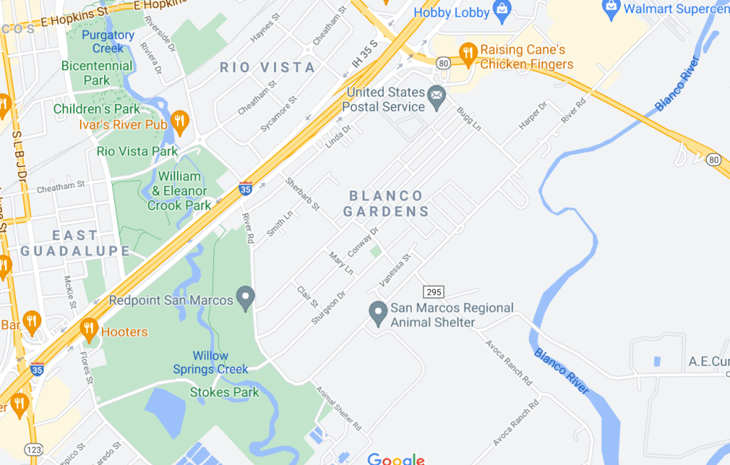
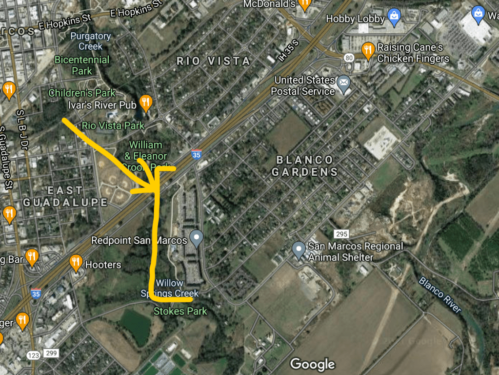
Here’s a map of Blanco Gardens, and the addition of the apartment complex.:

There was a huge outcry and wave of activism against the Woods, and council approved it anyway. (There was a second complex right at the headwaters that was barely defeated at roughly the same time.) As a result, that city council was mostly voted out of office and replaced with more progressive councilmembers. (Thomaides and Scott were both voted out in this wave.)

But the apartment complex got built, and currently exists.

2. The Flood

THEN! In 2015, the Woods was partially built when the Memorial Day Floods happened. The Blanco River rose 40 feet. 11 people died in Hays County. Homes and property were destroyed. The community was traumatized. It was a mass natural disaster.

Along with several other neighborhoods, Blanco Gardens had several feet of standing water. The town uniformly believes that The Woods caused Blanco Gardens to flood.

Is that true? It’s hard for me to say.

  • The flooding came in from The Blanco river primarily, not the San Marcos River.
  • The San Marcos River does meet up with the Blanco River just past this intersection, so when the Blanco floods, the San Marcos River backs up.
  • Apparently in four hours, the San Marcos River went from 700 cubic feet of water per second to over 70,000 CFS.

So, the water came in from the north part of the neighborhood, from the Blanco river. The issue is whether or not The Woods prevented Blanco Gardens from draining into the San Marcos river.

I saw an engineer’s presentation to the city claiming that The Woods did not cause Blanco Gardens to flood – and I frankly didn’t buy it. It smelled like computer modelling bullshit to me, with too many simplifying assumptions to be worth anything. Furthermore, he kept trying to use The Woods as if it were already built according to plan, as opposed to a messy construction site with sand bags over the drains to keep construction detritus from entering the waterways. He seemed to feel that the null hypothesis was that The Woods wasn’t a problem, and the analysis was too hard and complex to decisively disprove that.

At the same time, the amount of water that came down on Hays County that day is beyond comprehension, and it’s also true that it would have been a mass catastrophe no matter what. But Blanco Gardens might have had less damage.

The net result: The Woods still exists, but there is a lot of anger that is loosely divided into political camps, focused on this stretch of the river.

3. The damage to Cape’s Dam

What does all this have to do with Cape’s Dam? Behind The Woods, the river splits. This is manmade, dating to 1866. The river was dammed, and a cement channel was built to power a mill. The dam holding the main river is Cape’s dam, and the this cement channel that goes to the left is the Mill Race. The Mill Race is 1/4 mile long, and then they meet up again.

(Honestly, the geography of this thing is difficult to figure out, because it’s so hidden from the public view. And there are other nearby dams and channels that make it tough to figure out from Google WorldView. But I’m pretty sure this is right.)

Before the flood, the Mill Race was used mostly by a private company, Olympic Kayak Company, to rent out kayaks and such for recreation. In theory, it’s public land, but it’s never been publicly accessibly in any way, except via this private company or insider knowledge. I think both parts of the river were used – under the dam on the main river, there’s supposedly a beautiful swimming hole, and the mill race channel was nice and calm for people learning to kayak. But I’ve never seen any of this for myself.

In the 2015 flood, Cape’s Dam was severely damaged and the area was no longer safe for recreation. I remember hearing that it would cost millions to fix it and the Army Corp of Engineers recommends removal of old dams, not repairing them, so that the environment can return to its pre-existing state. At the time, there was federal disaster money available to remove the dam (but not to repair it). In 2016, City Council voted to remove the dam.

That’s when the owner of Olympic Kayak Company, Ben Kvanli, got involved, because of course this might affect his business model, along with another guy, Sam Brannon.

My opinion is that they approached this in bad faith. The legitimate position might have been, “This portion of the river is wonderful for recreation. We are going to advocate that it benefits the community to have these opportunities. Let’s balance the environment and safety with the benefits of recreation.” But they did not. Instead they threw everything but the kitchen sink at the problem. They formed an organization, Save the SMTX River (which you can google and find their link), and launched a campaign. My memory is that they had scientists saying that the science was not so clear cut – that the 100 years of growth had meant that endangered darter fish now thrived and their habitat would be destroyed if the dam were removed. But as of 2021, I can’t find any trace of who this might have been. Links are broken, citations aren’t there, so I don’t know who this counterpoint is.

The other major argument they made is that this dam has meaningful historical significance. Again, what? It’s old, but no one can seem to find any name or any event, or any architectural significance, or anything that merits more than a plaque saying “Here be ruins of ye old mill.”

One thing that clouds this is that Kvanli and Brannon are vocal rightwing Trump-style supporters (although this drama slightly precedes the most aggressive of Trump’s wave). As my URL suggests, I’m positioned on the opposite end, and it’s hard not to let that color my perception of these events. It certainly affected the lens that I saw this through as it was unfolding.

4. The current holding pattern

The federal money to remove the dam expired, and Council caved and agreed to not-decide quite so quickly. Commissions were organized.

The Historical Preservation Society tried to get it designated as a historical landmark, but they were denied at by the Planning & Zoning commission, and my memory is that the meeting was entirely about the subtext: that the designation was a farce in order to force the dam to be rebuilt and privilege recreation above the environmental concerns.

As of 2021, a long slow planning process is playing out. How will we balance recreation and the environment? What are the different options and how much will they cost? This is probably the appropriate way to proceed. “Proposed rehabilitation of the dam” shows up in the vision documents, but I’m not exactly sure what that will end up being.

October 6th 2019, at the Visioning Study Work Session:
Rockeymoore supported removing the dam
Marquez supported restoring the dam.
Saul Gonzalez wanted another opinion
Prewitt supported removing the dam
Melissa Derrick supported removing the dam
Mihalkanin supported restoring the dam
Jane Hughson said she was on the fence.

(Gonzalez, Derrick, and Hughson are still on the council.)

My personal opinion is that the recreation is important, the environment is important, and the historical significance is bunk. Remove the dam, and fund a solution that balances public recreation with environmental protection.

One big caveat: going forward, recreational uses need to be available to the public. It’s total bullshit that this one really cool stretch of the river has only been available through a private company, or people with insider knowledge.