
Citizen comment
Comments are a hodge-podge this week:
- Salvation Army was denied some grant funding, they’d like it restored.
- Demolition notices on Valley Street
- Rio Vista incident with SMPD that we heard about last time
- One person in favor of the Purgatory Creek rezoning, and one person opposed.
- Ok, this last one is fun. This guy wants to build a Glidescape in town, which is a solar powered roller rink, with vertical farms that grow fresh food, immersive STEM workshops, virtual reality tournaments, and planetarium, which can transform into a disaster-resistant facility when the community needs a shelter. He wants a Chapter 380 agreement and maybe some tax breaks to bring this vision to San Marcos.
I honestly assumed the speaker was maybe someone on a manic phase. But he seems to be an active person with a lot going on on this website and also this one? I still am not sure if San Marcos can support a planetarium-vertical-farm-roller rink, but we can’t know for sure until we try.
…
Item 1: San Marcos got a bunch of federal money after the 2015 floods, to help with recovery.
As of December 2024, the grants are all done. We’re officially done with flood recovery funds, and hopefully the community feels restored.
…
Items 2-3: Fiscal reports for April-May-June 2024 and July-August-September 2024.
We had ample warning that sales tax was coming in low, and we adjusted and pulled things back.
This is April-June:

The striped green and blue is what we thought we’d have. But then the solid green and blue are what we ended up having. But the solid blue is still less than the solid green, so our budget stayed balanced.
Then July-September looks even more back to normal:

Our sales tax was down because one specific business had their revenue way down. That’s supposed to go back to normal next year.
…
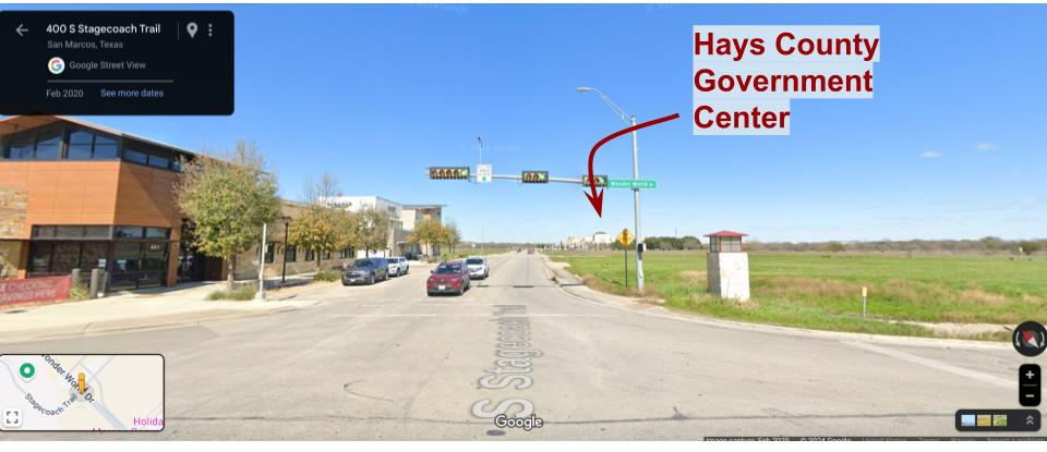
Items 19-21: The Hays Government Center is off Wonderworld, on Stagecoach:
All around it is a big chunk of undeveloped natural land:
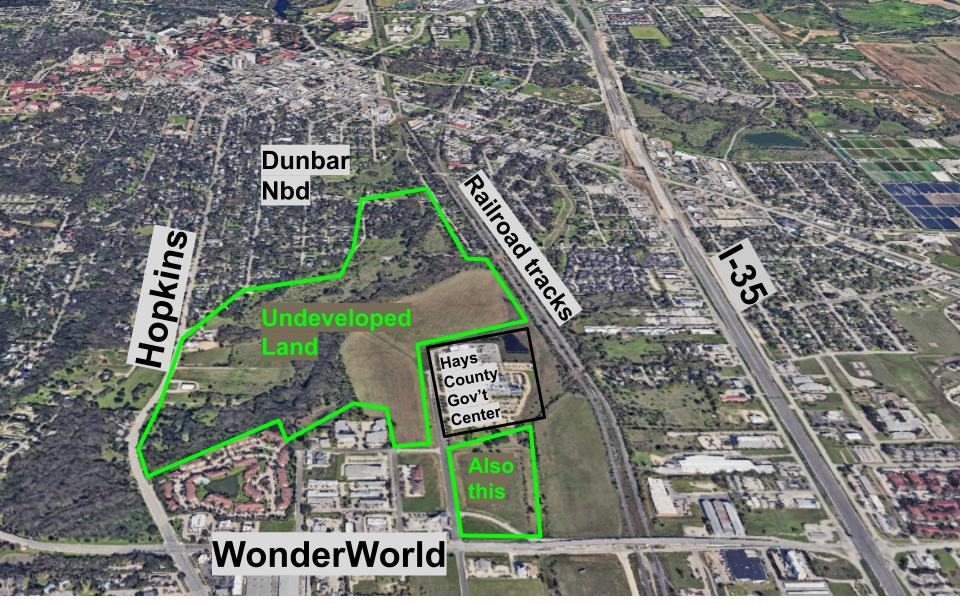
It separates the Dunbar neighborhood from Wonderworld.
It’s never been developed, mostly because Purgatory Creek and Willow Springs Creek both run through it:

So it can get very wet and marshy in there.
Way back in the 1980s, this land was all zoned Light Industrial and General Commercial:
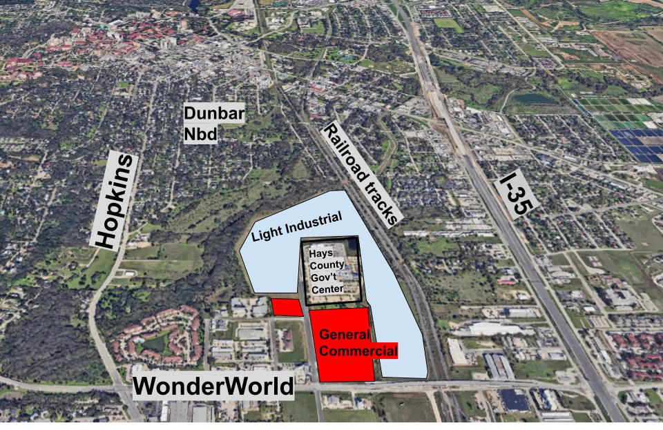
Here’s what General Commercial and Light Industrial mean:
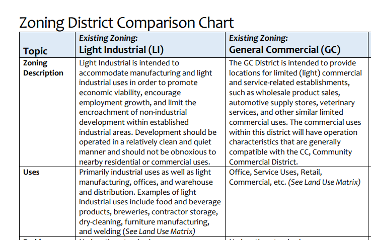
So the owner, currently, is allowed to build anything in that chart, without getting permission from the city.
Honestly, back in the 1980s, this area was basically outside of town. And the people in charge did not worry about Dunbar neighborhood flooding.
Fastforward to 2024
Now we do care about Dunbar flooding! How we’ve grown.
The city is working on the Purgatory Creek Mitigation Project, stretching from the river out to Purgatory:

(That’s my kludged-together map, joining Phase 1 and Phase 2.)
It’s going to be a big trench to help with flooding, with a big hike-and-bike trail running through it:

and the trail will connect the the river, through Dunbar, and over to Purgatory Creek Natural Area on Hunter and Wonderworld.
This trail cuts across the land that we’re talking about:

They’re calling this part of the trail “Hun-Dun” because it connects Hunter Road and Dunbar. Very cute, you all.
So the city approached the owner and asked about acquiring this land for that part of the trail:

The owner of the land said, “Well, as long as we’re looking at this land, what if we change it all around?” He is proposing the following zonings:

The green part will contain the Hun-Dun trail.
So what about the pink and blue parts?
First off, both are down-zoning. They are less intensive than Light Industrial and General Commercial. So that’s good, but it’s also pretty weak, because the old zonings were kind of ridiculous.
Blue will be CD-5. Mostly this means large apartment complexes. Pink will be CD-4, which usually means slightly smaller complexes, or things like townhomes.
What did Council say?
There are two main themes to the conversation: flooding and new roads.
- Flooding. If all this housing is built, will it increase flooding in Dunbar? After all, it’s going to displace a bunch of water. That’s basically why this area hasn’t been built out yet.
Answer: According to our Land Development Code, you aren’t allowed to build something that makes flooding worse for people downstream.
Jane Hughson kind of laughs darkly, saying “We know how well that works.”
Amanda Rodriguez asks exactly how this gets enforced?
Answer: It’s prepared and checked by engineers.
Note: “Prepared and checked by engineers” is all well and good, but that’s not enforcement. What happens if the builder cuts a bunch of corners? Enforcement has to come after that. Will city staff actually withhold their building permit and require them to fix it? Or will we just good-naturedly punch them on the shoulder and say, “Bro! You know better! Try not to do this again, but here’s your permit.”
The answer is: who knows! That step is invisible.
The second enforcement comes with maintenance: if you have a retention pond, do you check the drain and pumps regularly? Does the city? What happens if the drains get clogged and no one pays to have them cleaned? Will the city actually remove your permit? Or will they just wring their hands and say, “I hope this gets fixed!”
2. The roads
Which roads should connect into this new neighborhood?
Councilmembers talk in particular about Gravel Road and Bintu road:

Gravel Road is a sleepy little dead-end with some houses on it. Bintu is a sleepy little road with a Holiday Inn on it.
Here’s the Transportation Master Plan:
So you can see that in theory, MLK and Gravel are both going to be extended across Purgatory Creek, into this new neighborhood. And Bintu is supposed to be extended across the tracks, to connect the I-35 frontage road into the neighborhood.
Is this a good idea?
It depends!!
Bintu Road extension: Yes, I think this is a great idea. No one lives there. Another way to get across the tracks would be great. Let’s do it.
Gravel Road and MLK extensions:
If you have two sleepy neighborhoods that are back-to-back, it is generally a good idea to connect them. You want the people in these neighborhoods to have multiple ways to leave in case of flooding, for example. Connectivity is good.
However! If you connect two sleepy neighborhoods and Gravel Road becomes the New I-35 Workaround, then that’s a whole lot of traffic that these neighbors didn’t bargain for. All of a sudden, cars are zooming down Gravel Road at 50 mph.
At the same time, the city does need more roads running parallel to I-35, aside from just Hopkins. Maybe MLK? (My vote is also for Leah Drive, on the east side, and to extend the road that runs by Target, Barnes Drive, all the way to Wonderworld.)
Answer: Stay tuned! This will be a fiery debate when the Transportation Master Plan comes up for revision in the next 1-2 years!
…
Here’s the bottom line: currently, the developer is allowed to build all kinds of nasty things. Our hands are tied here. We’re not zoning new, rural land. We’re re-zoning land where the owner has current rights to build all sorts of things. This is a least-bad-decision.
Each part – blue, pink, green – gets its own vote:

The Blue Vote: Should the blue part be big apartment complexes?

The Pink Vote: Should the pink part be smaller scale dense housing, like townhomes?

I probably would have voted yes. It’s a good place for town homes and moderately dense housing. We just have to be thoughtful about the Transportation Master Plan.
The Green Vote: Should the green part be set aside for the trail?

That last one is easy.
One final note: The developer says he doesn’t actually have any plans right now. This is not going to be immediately developed in the next 2-3 years.
