
Citizen Comment:
- We just picked land for the fire station that is supposed to cover the SMART Terminal land. Why did we go with the only choice that is outside San Marcos ETJ, and in the Martindale ETJ?
- Hooray for can ban
- Hooray for the can ban, but take a closer look at the No Zones and Go Zones please. On a windy day, all that trash is going to blow from the Go Zones into the No Zones.
- Hooray for bringing back PDDs. Consider charging fees to cover staff time.
I’m also surprised that we’re moving forward with the fire station, although I guess you want to pick out land long before anything gets built. There have not been any public updates on the SMART/Axis Terminal since last summer.
…
Items 3-5: This little triangle at the corner of East McCarty and Rattler Road:

was annexed and zoned.
The plan is for it to be a gas station with car wash along the part facing McCarty, and then a strip mall along the back part that opens onto Rattler Road. The developer is hoping for things like restaurants, medical offices, some commerce, etc.
There’s a larger context:

this whole dead spot between the high school and the city is supposed to someday turn into a thriving East Village city center. (According to the Area Plans, which are in progress. This is supposed to accompany VisionSMTX.)
Point being: this is a good spot for a gas station and some commerce. You have my blessing, Young Developer.
No one really has any questions, and the vote is 6-0. (Mark Gleason is absent for this part.)
…
Item 6: Here comes your can ban!
So first, here are the Riverfront Parks that we’re talking about:
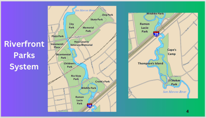
The plan is to carve out “No Zones” and “Go Zones”.
In a No Zone:
– Only reusable beverage containers
– Only coolers under 30 qts in size
– No containers under 5 oz, which is a little redundant, but we’re just doubling down on jello shots and mini-liquor bottles.
In a Go Zone:
– Go nuts. Have all the single-use beverage containers and giant coolers you want.
– Still no glass or alcohol or charcoal grills, but that’s not new.
So what are the boundaries?
It’s fuzzy! I thought there’d be a big conversation about it, but nope. None of the councilmembers had anything to say about these boundaries.
Here’s what was provided:


There are some trails to the right of Ramon Lucio park, in the map above. Those would all be No Zones, because there are so many river access points throughout.


Loosely speaking, it sounds like the big trails along the river will be the boundary of the No Zones. If you’re beyond the trails, you can pop that tab. If you’re closer to the river, you can’t.
My 2 cents? This is probably as good a starting point as any. It allows for plenty of big family picnics. The paths are already a big, visible feature, so it makes sense to use them as a boundary.
If we do a great job with the signs and communicate this boundary loud and clear, it’ll probably work. If we half-ass it, it’ll take a lot more effort to get people to change their behavior.
More details:
– It’ll kick in on May 1st
– The first year will be focused on education. Citations, etc won’t really kick in hard until 2025.
At the January workshop, there was a lot of conversation about hiring more staffing. Specifically, are we going to hire city marshals (who dress like cops), or will we hire park rangers (who dress like park rangers)? Nobody discussed this on Tuesday. So it’s still an open question.
Jane Hughson had a few questions, but they were extremely detail oriented – definition of banks of the river, clarity of exemptions for people cleaning up the river, that kind of thing.
The vote:
YAY for the can ban: everyone
Screw the river: no one.
This was a first vote, so it will come back around next meeting. But most likely, it’ll be here this summer!
